

Tempest Tours’ weather tracking guide Matthew Michell proposed to guest Becky Patel in front of a tornado near Arnett, Oklahoma on May 18. In the video, captured by Chris Gullikson, Patel is so surprised by the wedding proposal that she barely gives the approaching tornado a thought.
Tempest Tours intercepts “storm of the century”

On May 28, 2025, the Tempest Tours team captured what some are calling “The storm of the century.” The supercell thunderstorm tracked near Slapout, Oklahoma, in the evening and was captured on video by senior tour director Bill Reid. What makes the storm special is the exceptional “structure” it exhibits. This type of storm is called a “mothership supercell” since its circular shape mimics the look of an alien flying saucer. The shape is caused by wind shear, which causes the entire storm to spin counterclockwise.
Tempest Tours company announces record bookings after release of two new movies
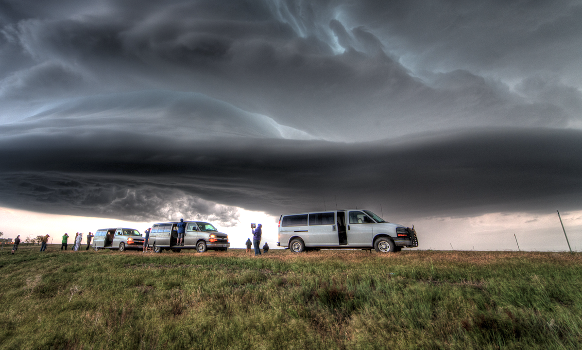
Tempest Tours has become America's destination for seeing big storms up-close. Photo: Chris Gullikson.
Texas-based Tempest Tours announced today that bookings for 2025 are sold out, and tours for 2026 are booking quickly. The company's founder and CEO Martin Lisius, also a veteran field tracker, said the stronger than normal interest in their product may be related to the release of two new films about storm chasing including "Twisters," a Hollywood movie that follows storm chasers as they track tornadoes, and "The Chasers of Tornado Alley: Touching the Sky," a documentary film written and directed by Lisius himself. "Typically, we would be almost sold out for 2025 at this point, but the additional interest in atmospheric generated by the two films probably has something to do with the accelerated bookings," he said. Tempest Tours started operations in 2001 with just a single van and three storm chasers. Over the years, it has grown and is now considered the premier severe weather tour operator in America leading tours for guests from around the world, including well-known VIP's. Lisius attributes their success to their focus on safety and education saying "Our guests want to be safe and to learn about weather. Safety and education have always been our mission." Lisius understands the importance of both more than most as the chairman of the Texas Severe Storms Association, a non-profit organization dedicated to severe weather education and public safety. Lisius worked as a technical advisor on "Twister" (1996). And, Tempest Tours "Tornado Wrangler" T-shirts can be seen worn by storm chasers in the new movie "Twisters."
Texas tour company to use its tornado tracking skills to help view solar eclipse
ARLINGTON, Texas - Long-range forecast models have recently predicted significant cloud cover across a large portion of the April 8th total solar eclipse US track which could hinder viewing conditions for millions of Americans. But, one Texas company will be prepared. Tempest Tours Severe Weather Expeditions, an adventure travel company founded by legendary field tracker Martin Lisius in 2000, will host a special total solar eclipse tour next week. Their mission is to travel from their base in Arlington to clear skies along the path of the eclipse for their guests to have an unobscured view of the event. “We’ve essentially been practicing for the upcoming eclipse for more than 20 years,” said Lisius. “When we chase storms, we target an area where we think tornadoes will occur later in the day, and that target may only be the size of a county or two.”
The company’s staff is comprised of meteorologists who specialize in predicting weather on a small scale, hours ahead of time. Once their target is defined, they depart in a fleet of specially-equipped vehicles in time to reach their destination.
“We are designed for this mission, and will do everything possible to reach clear skies prior to the start of the eclipse,” Lisius said.
This won’t be the first time the company has tackled a solar event. The team viewed the total solar eclipse on August 21, 2017. That day began with staff and guests under a thick deck of stratus clouds. They recognized something in the weather data and headed west to blue skies just in time to view the eclipse near Alliance, Nebraska.
“If Mother Nature provides just a single patch of blue, we will be under it.”
Contact: Brandi McGee, info@tempesttours.com, (817) 274-9313.
Solar Eclipse Tour web page: https://www.tempesttours.com/2024-tours/tour-1-awesome-april-tornado-tour-xr8yf-tz5m8-5tdpb
Company web links: https://www.tempesttours.com/ , https://www.facebook.com/tempesttours
Tempest Tours to Host Solar Eclipse Tour in Texas

Tempest Tours Storm Expeditions, a group of expert weather trackers based in Arlington, Texas, will host a special tour for the total solar eclipse event that will occur on April 8. The tour, which sold out within 36 hours last fall, will track the eclipse and offer a "taste of Texas" for its guests including a longhorn cattle drive, bluebonnet photography, and a sampling of Texas cuisine. The company's staff meteorologists will closely monitor the weather to find clear skies for its guests. "We are ready to travel wherever necessary to get them a cloud-free view of the eclipse," said Tempest Tours founder and president Martin Lisius, a 37-year veteran of field operations. "Forecasting and intercepting weather is what we do. The only thing different this time is we will be looking for the opposite of storms."
More information about Tempest Tours can be found at the company's web site, https://www.tempesttours.com
New storm chasing movie “Supercell” to premiere this week in North Texas

Severe thunderstorms are in the forecast for Dallas-Ft. Worth (DFW) and adjacent areas of north central Texas tomorrow, Thursday, March 16. Conditions will be favorable for a type of storm called a “supercell.” It’s a storm with a rotating updraft that is notorious for producing violent tornadoes and giant hail. So, it’s appropriate for the Tornado Alley premiere of a new movie about supercells to occur the very next day, Friday, March 17 in DFW.
The film’s director, Jamie Winterstern, will be on hand for the screening which will take place at 7:30 pm on March 17 at Galaxy Theaters Grandscape in The Colony, Texas. Mr. Winterstern will introduce the movie and speak with the audience.
Also on hand will be members of the Tempest Tours staff of storm chasers who took part in the production. They include Martin Lisius, Kim George, and Steve George. Tempest is an Arlington-based company specializing in storm chasing expeditions. They have hosted tours for guests from around the world for 23 years.
About “Supercell”
Baseball-size hail, violent winds, and churning tornadoes make supercells deadly, and when William Brody was a boy, his father – a legendary storm-chaser – was killed by one. Now, the family business belongs to Zane Rogers (Alec Baldwin), a reckless tour operator who sees dollar signs where others see storm clouds. When his destiny arrives in the form of one of the most powerful storms on record, William leaves his mom (Anne Heche) and home behind to team up with his father’s ex-partner, Roy Cameron (Skeet Ulrich), barely surviving a tornado yet determined to chase one of nature’s most terrifying creations: the bear’s cage.
Galaxy Theaters Grandscape is located at 5740 Grandscape Blvd. Ste. 100, The Colony, TX 75056.
Learn more about the movie at https://www.swipemarket.com/supercell
About Tempest Tours
Tempest Tours, Inc. was founded by Arlington’s Martin Lisius and legendary storm chaser William T. Reid in 2000. They host storm chasing expeditions in Tornado Alley during the spring and summer months. The team places emphasis on safety and education.
Learn more about Tempest Tours at https://www.tempesttours.com/storm-chasers
Contact: Kim George, Tempest Tours, (817) 274-9313, info@tempesttours.com
Team of Texas Storm Experts Deliver the Adventure of a Lifetime
ARLINGTON, Texas – It’s just March, but the late-spring experiential tours offered by one Texas-based company are nearly sold out. The company, Tempest Tours, Inc., has specialized in storm chasing tours since 2000. Their mission is to introduce the science and romance of chasing to guests from around the world with an emphasis on safety and education.
“We provide an educational experience to our guests while intercepting the best storm of the day,” said Tempest Tours founder and president, Martin Lisius. The ‘best storm of the day’ is almost always a supercell thunderstorm producing tornadoes, prolific lightning and dramatic skies somewhere in Tornado Alley, which stretches from Texas to North Dakota.
The Tempest team is led by Lisius and a group of highly-skilled storm chasers. Together, they have accumulated more than 200 years of experience.
Since 2003, the company has intercepted over 300 tornadoes for its guests who travel from as far away as Australia to get a glimpse of a twister. “Even though we can’t guarantee a tornado, we can promise our guests the opportunity to live the life of a real storm chaser for a few days,” Lisius said. “That in itself is an adventure of a lifetime for many of them.”
Tempest Tours will operate nine tours in 2022 from April through early July, the peak of tornado activity in the US. Fees start at $2640 Single ($2540 Double) for six days of storm chasing. Information, including tour schedule and rates, can be accessed on-line at www.tempesttours.com.
About Tempest Tours https://www.tempesttours.com/storm-chasers
Articles by Tempest Tours Staff https://www.tempesttours.com/storm-chasing-tours
FAQ’s https://www.tempesttours.com/faq
Schedule and Rates https://www.tempesttours.com/storm-chasing-tours
Media https://www.tempesttours.com/media
FOR IMMEDIATE RELEASE March 24, 2022
CONTACT INFORMATION:
Kim George
817.274.9313
info@tempesttours.com
“Dream” Type of Severe Weather Intercepts
By William T. Reid
As you may or may not know, as a field tracker, I am heavily inclined to favor meteorological targets on the High Plains versus the “Corn Belt” areas of Nebraska and Iowa. For me to venture near or east of the Missouri River, the (tornado) prospects have to be pretty good that way. For a day or two prior, the “Iowa play” was rearing its ugly head for June 28. This was in the middle of our Tour 7, so there were no logistical issues. We could easily do it. We tracked across the High Plains of western Nebraska on June 27th, and I had not looked very closely at the meteorology for the next day as I called for motel rooms in North Platte. Chris Gullikson had been directing the tour for a few days up until the 26th, and he was already heading east for Iowa. But he lives in Illinois, so that was a no-brainer! Iowa tends to be a big disappointment time-after-time for severe weather teams. It is easier to just stay out west and to give the tour guests the sure thing: the pretty and severe storms on the High Plains. I had not yet decided what to do as we headed for North Platte. The forecast charts showed nice instability and shear, though surface winds would be southwesterly. Something told me that I had better not ignore the Iowa play. And, I didn’t want to be besieged by a lot of pretty Iowa tornado pictures on Facebook twenty-four hours from now, especially by Chris. I told everyone to be ready to head east early the next morning.
As we headed east on I-80 on the morning of the 28th, it appeared that southwestern Iowa would be a good place to target. SPC had an enhanced risk, a 5-percent tornado risk, and a 30% hatched hail risk covering southwestern Iowa and extending into east-central Iowa. From the forecast charts that I was eyeballing, it did not appear necessary to venture well into the state. The forecast models with the “CAMs” (convection allowing models) showed thunderstorm development in or near extreme southwestern Iowa by mid-late afternoon, with very decent supercell and significant tornado numbers forecast to be in place. I was happy!
By about noon we were exiting I-80 in Lincoln and we found a fairly quick lunch stop. From there we continued east to Nebraska City, into Iowa and southeast on I-29 to Hamburg, and then east about 15-20 miles. This put us just a few miles north of the IA/MO border, in nice, gently rolling cornfields with great views of the sky and in a great road network. I felt comfortable here, there was good surface moisture convergence here, dew points were well into the 70s, and some storm towers were starting to develop to our southwest. This isn’t bad at all!
It was just after 3 p.m. CDT when the photo above was snapped. This activity struggled to get strong as it moved towards our location. The cap was rather strong, but it should be breakable this afternoon. To our distant northwest, in the haze and murk, a storm anvil materialized, and radar was showing a rapidly developing cell with some strong returns. It was pretty close to Nebraska City and moving to the east-northeast. Wow — that might be the one we want, and it will be an easy intercept, I thought. I went back outside the van to look at the struggling towers, now not too far to our south. I could stick with these, or head to the new storm that was only 20 miles away. “Get in the vans!”
This was one of those “dream” type of severe weather intercepts. In just 15 to 20 minutes or so we would be close to a developing storm in a tornado watch in mid-afternoon. With dew points this high and with the supercell and tornado parameter numbers so good, I just KNEW that our group was in for quite the show. We headed north perhaps ten miles, with a couple of short jogs to the west via the small town of Farragut. I typically give the tour quite a bit of space from a storm early on to view the structure, but as we neared, the base of the storm already had “that look.” I needed to get our group underneath the base. We stopped a couple of miles east of a good lowered area along 350th Avenue, just north of Highway 2. This was about halfway between Sidney and Shenandoah, in eastern Fremont County. The base had a good lowered area, and it looked about ready to get serious. Maybe five minutes later, a decent funnel cloud was halfway to the ground, and I was on the phone to the National Weather Service. A tornado was about seven miles west of Shenandoah and moving towards the town! The time was 3:45 p.m CDT.
With a good-sized tornado just down the road and approaching the tour group, I was a little nervous. We went another mile and a half east and stopped along the gentle curve along Highway 2, still a little west of the airport.
So, it was time to get east again to make sure that we were in position for perhaps another show. This storm would probably want to do it again. We went east past Shenandoah by a couple of miles and stopped near a hilltop. This gave us a good look at the storm structure. A skinny funnel cloud continued, adjacent to a prominent, persistent, and ominous wall cloud.
I tried to shoot some video at this stage, and I think it was here that we started to get bombarded with nearby CGs (cloud-to-ground lightning bolts). It was difficult to decide whether to stay alive inside of the van or to risk getting struck while watching the slinky funnel! The shots above were around 4:06 p.m. CDT.
I was not enamored with this vantage point, and we went a few more miles east and found a splendid hilltop with a great view of the storm. This was about halfway between Shenandoah and Yorktown and just south of Highway 2. From here I could set up my camcorder on a tripod and relax some. There was no tornado currently, and no nearby CG activity. The updraft base was a little north of Highway 2 now and to our WNW to NW. It looked like it was fixin’ to make a big tornado. Again we scooted a couple of miles to the east, and the tornado had vanished. I was surprised that this was not a long-lived tornado.
During the next couple of re-positionings to the east, past Yorktown and to Clarinda, our eyes were diverted to the south. Intense convection was in progress in that direction, perhaps 12 miles distant. Our nearby storm continued to look quite healthy, and quite potent. It had stopped producing tornadoes, however. Why was that? Well, the newer storms towards the south were intercepting the really good, really moist surface winds. We watched the massive wall cloud to our northwest for a few more minutes — probably longer than we should have — before diving south from Clarinda.
The storm was moving to the east, and maybe to the east-northeast. A river was paralleling our road on the east side, and there were few options east before Braddyville. It looked like I had to head all of the way south to Road JJ in Missouri, just south of Braddyville, before I could get east. I was not aware of the road east out of Braddyville, which might have saved us several minutes. The storm was strong and wrapping up nicely to our east, but we were on the wrong side and precipitation was hiding the stuff that we wanted to see. This was aggravating now, and the terrain and road network were not nearly as good as one hour ago!
As we headed east on Road JJ, we were treated to occasional views of the impressive mesocyclone that was now to our east-northeast. The road jogged north a mile and then south a mile on the way to Hopkins. These were valuable minutes lost, and we could not make great time anyway on this narrow and wet road on the edge of Missouri. Finally, we were moving through Hopkins, Missouri, and the supercell was to our east-northeast still. Road 148 headed back into Iowa to the northeast, and that could get us kind of close to the updraft base. I knew that the storm was cranking and rotating hard at this time, and probably had a significant tornado with it.
A lowering and perhaps a tornado are attached to the storm base. This was truly a beast of a storm! It was south of Bedford, Iowa, by a few miles, and the time was about 5:12 p.m. CDT. I was discouraged with the trees and poor road network and our poor positioning as the storm continued to move to the east. We stopped in a relatively open area to get some shots of the storm to the east, and here we found giant hail in the grass along the road, some a good 3-to-4 inches in diameter! There were some new cells nearby now, and they looked interesting, but they were not strong.
I elected to try to get back in front of the “main event” storm. We went to Bedford and then east. The radar suggested that this target storm was currently not nearly as strong, as a number of cells developed east-west along the state line. We had to wait near Irena, Missouri, for about 20 minutes for a storm’s hail core to clear our route to the south. We finally came out on the south side of the strong storms, but the activity was a bit disorganized and cool outflow from the north was in progress. There was still plenty of daylight remaining. Whereto next?
New storms were going up to our west, in extreme northwestern Missouri. It was time to check those out. West we headed to Maryville and a really quick pit stop. I don’t think we had had one since lunch — yikes! A very electrified storm cell was approaching Maryville, and I was anxious to get into position and out of the way of its heavy core! The images below were at about 8:10 p.m. CDT, and south of Maryville by a few miles.
Mother Nature had one more treat for us. About six or seven miles south of Maryville, another tornado developed to our west. This one quickly wrapped in rain, but it was visible again several minutes later in its weakening phase as the precipitation thinned some. This was from about 8:20 to 8:25 p.m. CDT. Another very nice supercell was organizing to the east at this time, but we did not observe a tornado with this one.
We went up and down U.S. 71 a few times to monitor storms, south of Maryville. One base, directly overhead, spun scud around at a rapid pace which looked surreal. It was soon dark, and time to head south into Saint Joseph for the night. It had been an interesting and entertaining 24 hours since I decided that we were going to go to Iowa
June 28, 2018, was over, and it had been a doozy!
By William T. Reid
By June 28 in 2018, I had been chasing and leading the chase tours for two full months, save for a couple of 4-day breaks. The spring chase season had thus far been woefully short on tornadoes on the Great Plains, and I had had only a few days with tornadoes observed. These were relatively low-end tornadoes. There were a handful of somewhat high-end tornadic events during May and June, but only one or two of these were reasonably forecastable, and my forecasts on these days fell unreasonably short.
Anyhow, enough with the woe-is-me part, because the chase tour and I hit the jackpot on June 28th in extreme southeastern Montana and into extreme northwestern South Dakota. A season’s worth of severe-storm mediocrity was wiped away in about two hours. Here is the story.
The outlook for June 28 in the Dakotas was looking pretty darn good several days out, with SPC outlining a slight risk in their Day 4 convective outlook (issued on June 25). Fortunately, this date was the second-to-last chase day for the Tour 7 group (with guides Tom Trott and Craig Wolter), so there were no logistical travel issues. We chased in the Bowman, ND, area on June 26th, toured the Badlands on the 27th, and were positioned nicely at breakfast time on the 28th, in Belle Fourche. SPC showed a moderate risk for much of North Dakota on their Day One outlooks, but they dropped the healthy 10 percent tornado risk in their 13Z outlook to 5 percent for the 1630Z Day One outlook.
No biggie — it still appeared to be shaping up to be a great chase day somewhere in western North Dakota and vicinity. A surface low was in eastern Wyoming, and very moist, backed winds were forecast northeast of the low for the afternoon and evening, in eastern MT, northwestern SD, and western ND. With an approaching upper-level disturbance and 500 winds blowing at 40-50 knots from the WSW, the wind shear was looking fantastic. Belle Fourche was muggy and overcast through mid-morning, but bright sunshine ruled the region by late morning. The BIG factor which this chase day had going for it (that most others this season did not) was quality moisture! Dew points were well into the 70s over all of western SD mid-morning, with low 70s seeping nicely into southeastern MT and southwestern ND. This great moist air was NOT forecast to mix out during the day. It would be in place to meet and greet any thunderstorm that might roll through the region. The forecast instability was fantastic, with CAPE values well over 5000 J/kg. The quality moisture should ensure low storm bases, and the strong storm-relative inflow and superb wind profiles just above the surface would promote tornadoes. Now all I had to do was to make sure that I wound up on the right storm! I let the tour group know in the morning briefing that all of the parameters were looking super, and that their chances of seeing a tornado this day were about 50 percent.
The easiest chase decision of the day was to head north out of Belle Fourche. We needed to be north-to-northeast of the surface low, in the moist east to east-southeasterlies. That was the easy part. SPC was talking about a warm front lifting north during the day towards Canada. Of course, a storm on the warm front would be a great tornado candidate. The forecast charts, to my eyes, looked to favor the area bounded by about Buffalo, SD; Baker, MT; and Bowman, ND. This area was a little south of the forecast position of the warm front towards early evening. The forecast maps showed the warm front up around or north of I-94 later in the day. The CAMs (convection-allowing models) during the morning showed a handful of rotating storms in and around western ND by early evening. The chase target was not particularly clear-cut. Would we need to be well up into North Dakota, perhaps north of I-94? This was in the middle of the western part of the moderate risk area, and might seem at first glance to be a good starting point. Would we need to be in eastern Montana, around Glendive or Sidney, where very moist east winds were in place and where initiation might be more likely? I did not know yet. We had an embarrassingly short drive north to Buffalo and stopped for lunch.
From Buffalo, I figured that it would be prudent to get a little farther north. Buffalo was kind of near the southern edge of the severe risk and tornado risk outlines by SPC. More options would remain open by heading north. I was thinking that I might eventually need to head west to Baker on Route 12, and perhaps north from there. One thing that concerned me was the rather dreadful road network in southwestern North Dakota. This area sports a pathetically sparse paved road network, and I knew that I didn’t want to wind up too far west with something big going up to my east and moving east…and with no handy road to get there. That was my nightmare scenario for this day. Just keep your options open, Bill, until it is obvious as to where you need to be!
Our group stopped in Rhame, ND (west of Bowman) for a couple of hours as I monitored the weather conditions online. Fortunately, there was a nice, cool cafe in which to hang out, as it was dreadfully warm and humid and uncomfortable outside. By 3 or 4 p.m., some weak convective towers were scattered about, but the sunshine ruled and it felt better to be eating ice cream indoors. The HRRR model runs during this afternoon were fairly consistent in showing a big cell trucking through northern Harding County (just north of Buffalo, SD) towards sunset. I knew that if this did indeed transpire, that it would be privy to all of the impressive severe-weather ingredients and would make our group very happy. A Harding County storm intercept would be a snap from Rhame — just minutes away! But there was that warm front to consider. And it seemed that most other chasers were clustered along I-94 from Dickenson to the Montana line. And, a storm was now getting going and was in a great environment up towards Watford City, north of I-94 a bit. Would that one be the main show? I would probably be headed to that one if I were currently up on I-94 at Belfield. But I was trying to stick to my Baker-Buffalo-Bowman guns. The storm environment appeared to be a notch or two better down here at Rhame compared to that north of I-94. Moisture and winds were better down here. As the afternoon dragged on though, it was becoming clearer that storm initiation would NOT occur anywhere close to Rhame, or to my target area. The cap was rather strong here, and the cumulus towers were weak. Surface moisture convergence was becoming less strong in this region. Hmmm.
As 4:30 p.m. came and went, I decided to head over to Bowman, about 12 miles to the east. A fast north option was here, if needed (U.S. 85). I was still thinking that the I-94 area and that less-than-obvious warm front might be where I needed to be. On radar, that Watford City storm looked okay, but not super. I was having difficulty seeing the warm front in the current surface observations. Buffalo, to our south, still showed ESE winds. During the fuel stop and pit stop at Bowman, I checked the latest visible satellite loop. There it was — a quickly expanding storm anvil well to our southwest, a little ways south or southwest of Broadus! Well, that wasn’t really where I wanted it to be, as it was perhaps 120 miles away. But, it was still very early, and that activity should eventually approach my target area. My second easy decision of the day was made —- let’s go get it, gang!
We headed south to Buffalo, west to Camp Crook, and to the SD/MT border a little southwest of Camp Crook. Pavement ends at Montana! The Broadus-area storms had evolved from a loose and disorganized group and into a dominating supercell. The large storm anvil was beginning to surge overhead. Occasional CGs were spotted, too, but some elevated Montana terrain effectively blocked that which we aspired to observe to our southwest. We went perhaps six miles west on Tie Creek Road from the state line (near Camp Crook) and stopped. This road continued WNW-ward to paved route 323. We watched the approaching storm from here for maybe five-ten minutes, and it was a lousy spot because of the hills to our west and southwest. I didn’t want to go any farther WNW on this gravel road, and I wanted to see the storm updraft that was moving towards us from Broadus. We went back east to the state line, and then south on Camp Crook Road. This took us south-southwestward to Albion via Capitol. I had been on this stretch of road once before, from Camp Crook to Capitol, but not beyond to Albion. It was a great gravel road, fortunately. After about 30 miles, we were at Albion and paved road 323. A fantastic and sculpted supercell updraft was to our west — woohoo!
From the ghost town of Albion, we headed northwest on 323 a few miles and stopped (around 6:45 p.m. MDT/0045Z) to watch the rotating updraft. The supercell was to our west or WNW, and moving to the ENE, so it would move to our NW and N. Here we had plenty of time to set up the tripods and the time-lapse cameras and to admire the storm. There was perhaps a shallow lowering with the storm base on occasion, but the storm was in no hurry — yet — to make tornadoes.
The structure with this supercell was about the best I had seen all spring! The funny thing, looking back, is that I was not really contemplating about what might occur in the not-too-distant future. It had escaped me for the time being that the storm was headed right into this superb environment for tornado development. Maybe I was just too deep into my 2018 mindset. In 2018, storm chasers had been conditioned to expect a tornado no-show. But, I WAS contemplating my road options now. The supercell was tracking east-northeastward across 323, perhaps 10-13 miles northwest of Albion. If I stuck to paved roads the rest of the way on this chase, then I would have to go all of the way southeast to Belle Fourche, and then north-northeast to Buffalo. That would get me to the No. 3 Saloon in Buffalo sometime during the Day 4-8 timeframe, and this storm would be a few rotating water molecules in Latvia. That narrow gravel road back up to Capitol would be THE ONLY WAY to stay close.
As the leading edge of the updraft base neared, to our northwest, the action area (to the NNW) began to stir. An obvious but bewildering shroud of dust materialized beneath a — beneath a — well, beneath where a tornado would be if one were to form. A funnel cloud was still absent. The images below were taken at about 7:11 p.m. and 7:15 p.m. MDT (0111Z and 0115Z), about 30 minutes after we had arrived at this spot along Highway 323.
Yes, the storm base was quite low, and yes, there was a great big RFD cut slicing into this updraft base, and it was looking like tornado-time! But what was this massive area of obscuring phenomena?! It was probably a mix of dust and precipitation, and after a few minutes a tornado decided to make itself visible in the murk! I estimate that it was about 7-9 miles distant.
The tornado seemed to do another disappearing act, and I had the gang back in the vans quickly. We really needed to get ourselves into better position. We had to go a few miles southeast, away from the tornado, in order to get to our north-to-northeast option at Albion. This would take a little time, of course. But in a minute or two, the guests were shouting that the tornado was visible again! I didn’t want to stop. We needed to get into better position. But one never knows if this will be “THE Show” or not, so we stopped again and I got more shots with the long (70-200mm) lens.
This was the first tornado of the chase day, the first tornado produced by this supercell. I knew that it would not be the only one. I was now hellbent on getting the tour group a lot closer to the action area of this magnificent storm. This gravel road which headed north-northeastward from Albion was just about perfect…except that it was a gravel road! The supercell was going to rain on it, and it might become sloppy and problematic. If we got stuck, it would be hours to get any help. Or maybe days. Or months. Is there cell service here? Does anyone live around here? But, we had just been on the road an hour prior, and it seemed like it would be manageable in wet conditions. We were soon on Camp Crook Road again, and headed north-northeastward along the Little Missouri River. The supercell was fixin’ to work its magic up ahead.
A new action area was evident to our north. The base was black and beckoning and maybe five miles away. We needed to get up to it! A good-sized funnel descended very quickly, and Tornado #2 was in progress! We were about 4-5 miles northeast of Albion as this transpired, not quite to the kink in Camp Crook Road which crosses the Little Missouri. This tornado was much closer than the previous one, and the guests were anxious to stop right away to get out of the van to watch! But we needed to cross the river first.
It was amazing how quickly this funnel developed! Note the impressively large and lower storm base to the north of this tornado. After an excruciating couple of minutes of positioning, we found an area with no trees blocking the view. It was time to stop and to shoot the tube!
Tornado #2 was perhaps four miles distant to our NNW or N, or about 10-12 miles southwest of Capitol, Montana (in Carter County). My camera time stamps for this tornado, from this stopping point, are from 7:45 to 7:48 p.m. (0145Z to 0148Z). It looked to be weakening a little, but was still in progress when I decided that we needed to get ourselves farther up the road. The supercell was really going into “tornado machine mode” now.
Tornado #2 disappeared about as quickly as it appeared once we were rolling again. I would estimate its timeframe as from 7:42 p.m. to 7:50 p.m. MDT. Now in our sights was a healthy rotating wall cloud, and it was practically sitting on Camp Crook Road.
Precipitation curtains are visible on the south and southeast sides of the lowest part of the storm base. This was a developing tornadic mesocyclone, and another tornado was imminent! We continued towards the tight area of rotation, which involved darting through a couple of fast-moving curtains of heavy rain and hail. These bouts with rain were brief, fortunately. After about 6 or 7 miles from our previous spot, we stopped again to watch Tornado #3 develop.
The tornado touched down perhaps 1.5 miles away, to our northeast. This would put it about four miles SSW to S of the little enclave of Capitol. I was surprised that the tornado emerged out of the gray area on the right side of the road, and not from the blacker area to its left from our perspective. I ran back to the van to grab the Canon with the long lens. We could easily hear the tornado now.
The tornado was moving to the east or northeast rather slowly, and there was an opportunity to get even closer. Thank goodness for Camp Crook Road! Tom and Craig steered the vans and its incredulous stormchasers closer to Capitol.
It was a little wet and windy out here in the field, with occasional small hail. Big surprise, right! We cared little about our comfort level as we marveled at this spectacle.
I think we were here for just a couple of minutes. As the tornado continued across the Montana/South Dakota border, just southeast of Capitol, we scampered north to Capitol and then east to try to stay relatively close.
We stopped within a stone’s throw of the state line, in rain and some small hail. The tornado was now almost due east of us, and it roped out perhaps 2 miles distant.
Wow— that was quite a ride! Thank goodness that the gravel road(s) were awesome, as were my drivers! And thank goodness that I had not been lulled towards some other storm earlier this day!
For this long-lived Tornado #3, my camera time stamps show a beginning time of about 8:04 p.m. and an ending time of about 8:27 p.m. MDT (0204Z to 0227Z), or nearly 25 minutes in duration. I estimate that it tracked from about 3-4 miles SSW of Capitol to 3-4 miles E to ENE of Capitol, winding up (or winding down) a mile or two into South Dakota.
Our east road from Capitol ended a mile into South Dakota, and upon stopping ANOTHER new tornado had formed, maybe five miles to our east! This was Tornado #4, and the time was 8:30 p.m. MDT/0230Z.
There was no way to quickly drive closer to this tornado. We were now along South Camp Crook Road, and the next road eastbound was about seven miles to the south. Since the storm was headed more to the east-northeast, I elected to head north to Camp Crook, about a ten-mile drive. We quickly lost sight of Tornado #4 behind the storm’s precipitation core. Our next stop was along Route 20 in Harding County, perhaps four miles east-northeast of Camp Crook. It was past sunset now, and with dusk upon the land we had a good look at the backside of the storm to our east…and a poor look at another tornado to our south! The contrast was dismal, and the light was very poor, but there was a good-sized and tall stovepipe tornado to our south or south-southeast. This persisted for several minutes at least. Was this one the final stage of Tornado #4, which we had observed in its initial stages some 15-20 minutes earlier? I don’t know. But, I think the chances are good that these two tornado “sightings” were from the same meso or tornado cyclone, and there is a good chance that this was indeed the same tornado.
The tornado was moving generally towards us, from south to north, so it was a little easier to see as it was finally roping out. It dissipated only a few miles away. Again, I categorize this tornado (or “intermittent” tornado) as the same one spotted at 8:30 p.m., east of Capitol. Its ending time was approximately 8:59 p.m. MDT (0259Z).
I can’t recall for sure, but I think that we drove another mile or two eastbound towards Buffalo. It was dark out now, but plenty of lightning was providing a good show in the updraft to our east. The storm was blocking our path to Buffalo for the time-being, and it didn’t seem like a good idea to drive into this storm! So, we stopped and got out to watch the backside of the storm along the deserted highway. After a lightning flash or two to the east, guests were seeing a tornado shape! It was Tornado #5, and this was another good-sized and long-lived tornado which we could easily photograph courtesy of the lightning flashes. I was lazy and didn’t put a camera on a tripod. The survey by NWS Rapid City show this tornado some five miles or so to our east to east-northeast.
Another impressive lowering loomed just southeast of the area where Tornado #5 roped out. I phoned the NWS in Rapid City again (for the third time today) to let them know what I was seeing. It looked like the storm was ready to produce another tornado, perhaps close to the town of Buffalo. But one did not form, as far as we could see, and the storm updraft began to slowly diminish in strength. We made our way into Buffalo, where many were lined up along the sidewalks and watching the sky. I wonder what these folks witnessed in the past hour or two?! The convenience stores were closed in town, and we headed south to Belle Fourche for the night. The chase day of June 28, 2018, was over, and it had been a doozy!
Check out the NWS Rapid City survey page for additional info on the tornadoes in South Dakota, including some great radar images. The NWS Billings page has information for the tornadoes on the Montana side.
I count five tornadoes for this event, but there may have been more than that. A relatively brief and weak anticyclonic tornado was documented about the time that the large Capitol tornado was getting strong, but we did not observe it. The tornado from about 8:30 to 9:00 p.m. MDT, southeast of Camp Crook, SD, is counted as two tornadoes by NWS Rapid City. I count it as one intermittent tornado, since it was likely from the same meso/radar couplet of the supercell.
SUMMARY
Here is a summary with the approximate times of the tornadoes, according to my camera time stamps:
Tornado #1, about 10-13 miles NW to NNW of Albion, Montana in Carter County, 7:15 to 7:35 p.m. MDT (0115Z to 0135Z). NWS Billings reports that this tornado was spotted crossing Road 323 “about 12 miles north of Albion” in the Finger Butte area around 7:17 p.m. It was assigned a rating of EF0. It is possible that this tornado was intermittent, or two tornadoes, for the 20-minute time frame from 7:15 to 7:35 p.m. But, this tornado event was very likely from the same meso/radar couplet and should be counted as one tornado. The tornado was over open country and did no damage, but its look and longevity were rather impressive. I suspect that this tornado was capable of EF2 damage, perhaps even a little greater. The NWS had to assign EF0 due to the lack of damage and lack of access to anything impacted.
From the NWS Billings report:
Tornado 1 (EF-0):
Start: 45.3219, -104.4806 (717pm) End: 45.3548, -104.2803 (735pm)
Tornado on the ground for 10 miles. No damage visible from tornado. EF-0 microburst damage to the south of the tornado due to RFD included; 2 trees uprooted, barn roof blown off, shed destroyed, and a horse trailer flipped over.
Tornado #2, about 8-10 miles N to NNW of Albion, or about 10-12 miles SW of Capitol, Montana, in Carter County, 7:42 to 7:50 p.m. MDT (0142 to 0150Z). The NWS Billings survey describes this tornado (with perhaps the last part of Tornado #1, or perhaps with the very brief anticyclonic tornado at 8:01 p.m.?) as “two additional brief tornado touchdowns.” No damage occurred with these in the extremely rural areas. Tornado #2 was not brief and was indeed quite intense: see Tom’s video, Minute 4 to minute 6. It appeared quite capable of EF2 to EF3 damage for much of its 8-minute lifespan, covering a track of 2 to 3 miles at least. Tornado #2 should be, and is, rated EF0 since there was no damage.
From the NWS Billings report:
Tornado 2 (EF-0):
Start: 45.3503, -104.2066 (744pm) End 45.3573, -104.1321 (750pm)
Tornado on the ground for 4 miles (6 minutes). Rural areas. No reports of damage.
And an additional tornado, which we did not observe, from the NWS Billings report:
Tornado 3 (EF-0):
Start/End: 45.3675, -104.0981 (801pm)
Brief touchdown. No reports of damage. Reports indicate anti-cyclonic rotation.
This was likely the brief tornado observed by Silver Lining Tours, and the coordinates put it right along Camp Crook Road, not too far from where we were at there time, presumably just south of our location as we were heading north.
Tornado #3. I call the long-lived and large tornado near Capitol, Montana, “Tornado #3.” It occurred from about 8:04 to 8:27 p.m. MDT (0204Z to 0227Z) according to my camera timestamps. NWS Billings shows a rating of EF2 on the Montana side and EF3 on the South Dakota side.
I have the path from about 4 miles south-southwest of Capitol to about 3 to 4 miles east-northeast of Capitol, in South Dakota.
This was a strong-to-violent tornado, and if it had tracked through a heavily-developed area, would have likely caused EF4 damage. The NWS found evidence of EF3 damage.
From the NWS Billings report:
Tornado 4 (EF-2 in MT, EF3 in SD):
Start: 45.3753, -104.0813 (806pm)
Exit to SD: 45.4092, -104.0406 (820pm) End: 45.4475, -103.9904 (830pm)
Tornado on the ground for 7 miles (24 minutes) from south of Capitol, MT northeast into SD.
In MT: 3 mile long path, 200 yards wide. Damage ranged from EF-1 at the initial touchdown, increasing to EF-2 just before the SD border. Large tree limbs down and trees being snapped off, becoming more widespread as the path approached the Little Missouri River.
Max Estimated Wind Speed: 136 mph (EF-3)
Width: Ranged from 200 yards in MT to near 1?2 mile in SD / Length: Approximately 7 miles extending across MT and SD / Time on the ground: Approximately 24 minutes
Tornado #4 This event lasted from about 8:30 to 8:59 p.m. MDT (0230Z to 0259Z), and NWS Rapid City breaks it into two tornado events (the second and third tornadoes in their survey). It, or they, appear to have been from the same mesocyclone, so I will call it one “possibly intermittent” or “discontinuous” tornado. The track was fairly long, maybe 6 to 7 miles, from SSE of Camp Crook to SE of Camp Crook. NWS Rapid City reports that eyewitness and video evidence show that the northern-segment tornado in this “event” developed just north of the southern-segment tornado, but there is a five minute gap from the end of the first (8:30 to 8:38 p.m. MDT) to the start of the second (8:43 to 8:57 p.m. MDT).
NWS Rapid City found EF2 damage with the second tornado in their survey (the first one of the two here). The second one also appeared quite strong, but did not damage anything and was assigned a rating of EF0.
See the NWS Rapid City report for the details and tracks for Tornadoes #3, #4, and #5.
Tornado #5 I have this one from about 9:12 to 9:20 p.m. MDT (0212Z to 0220Z), and NWS Rapid City has it from 9:10 to 9:26 p.m. MDT. It moved north from near mile marker 17 on SR 20, which is about equidistant from Camp Crook and Buffalo. It received a rating of EF2, which is not surprising given its longevity and appearance in the lightning flashes.
The cyclic tornadic supercell which tracked from near Broadus, Montana; to Capitol, Montana; and to Buffalo, South Dakota lasted for about four hours, from about 6 p.m. to 10 p.m. MDT (00Z to 04Z). The tornadoes with it began at about 7:15 p.m. MDT and ended around 9:20 p.m. MDT (0115Z to 0320Z), a two-hour timeframe. Tornadoes were in progress for about 90 minutes during this two-hour period.
July 4, 2019 Chugwater, Wyoming Tornado
By William T. Reid
This was the second-to-last chase day for Tour 8, and the second-to-last chase day of the tour season for me. The setup was looking pretty good for supercells (and perhaps even tornadic supercells) in the “upslope” regime of eastern Wyoming. Upper-level winds were excellent, and moisture and sunshine on the high terrain meant great instability. With dew points pushing 60F in and around the Cheyenne Ridge, where elevations are near 6000 feet, a chaser gets a warm and fuzzy feeling inside. We started westward out of Valentine and aimed towards Scottsbluff…and probably west or southwest a little from there. The CAMs (convection allowing models) were relatively consistent on predicting a good-sized supercell tracking eastward through the Chugwater area by 00Z or so.
After lunch in Scottsbluff, I was beginning to feel less certain about the prospects later on around there and in southeastern Wyoming. The southern Nebraska Panhandle was still very cloudy and cool. I need sunshine! There would be no decent storm near here today, given this cool and stable air. Ugh. And, now the HRRR model seemed to be backing off some on its nice “Chugwater supercell” thinking. The skies were still partly cloudy in southeastern Wyoming, so sunshine was not too big of an issue to our west. But I figured that this cool low-level airmass that was moving westward into my target area would be detrimental. I looked at other areas — the Palmer Divide; the Sandhills back in western Cherry County, where we had been just two hours ago. The Palmer Divide had good moisture but so-so shear. The western Cherry County play looked halfway decent. I looked again at southeastern Wyoming. Dew points of 60F and afternoon sunshine around Cheyenne — you just don’t walk away from that! I decided to stick with Plan A. Chris Gullikson supported that thinking. I am glad that he was not too keen on straying somewhere else! Chris mentioned that the cool and cloudy conditions in the southern Panhandle, which persisted well into the afternoon, could be beneficial as the impressive low-level moisture was not mixing out. SPC also noted this in an afternoon mesoscale discussion.
We zigged and zagged to Chugwater, via Hawk Springs and Road 313. A good-sized storm was near the mountains almost due west of Chugwater. That was what we wanted! The road network around here is lousy, though, so we plopped ourselves onto a high point along the dirt road some 4 or 5 miles west of Chugwater and waited for the storm to near us and Interstate 25. The updraft was maybe more than 30 miles distant, but we had some decent views. Light anvil rain fell here, and soon the very low storm base came above the distant hills.
The storm moved ESE to east, so the base (and its action area) was eventually to our WSW. An obvious funnel cloud protruded for a minute or so, and the storm became tornado-warned. Slowly, slowly, slowly, it approached I-25 and the area not too far to our southwest. I was glad that we were on this storm, with the nice very clear skies to its east and southeast! What was there to worry about?! The easterly inflow was at least 15 knots, and the storm had great structure!
The base was to our southwest, and it was time to reposition. We made our way east to I-25 and the southern edge of Chugwater. Should I continue to the east a little, and get onto that nice plateau just to the east of Chiugwater? That would be a pretty good area to monitor the supercell, to maintain a good look at its structure, and to stay with it as it continued east of I-25. I was thinking that this would be the most prudent maneuver. But there was another play: we could get ourselves south a little, get right in front of the storm base, and watch the storm as it moves right up to the interstate. This second strategy was a bit risky, though. Once the storm moved east of the Interstate here, we would be basically out of luck for a while as far as getting back into position just east of the storm. The hail core would be between us and Road 313 eastbound out of Chugwater. There was a chance that we might miss any “show” if the storm decided to go into tornado-mode a few miles east of I-25.
I decided to “go for the gold” and to head south from Chugwater. The next exit was about 7 miles away. Would this be too far south? Too far north still? In 20 or 30 minutes, would I be behind the storm as it started to wrap up, just east of I-25, hiding big tornadoes from chasers on its west side? That was a real possibility. At our exit onto West Bear Creek Road, the storm was looking good. The base was looking REALLY good! I wanted to find a nice high spot for the group to watch, and drove west about 1.5 miles. A few chase teams were about, a couple near I-25. This was the place to be! Our unpaved road, right on the southern border of Platte County (with Laramie County to the south), curved quickly up to splendid hilltop, with a perfect look at the storm base, just to our NW. Yes!
The storm was very well-organized and low storm base. The storm was just 3-5 miles west of I-25, and southwest of Chugwater by 9-10 miles. Up to this point, the storm had produced only a brief tornado or funnel cloud.
No more than a few minutes after reaching this vantage point, the supercell decided that it was time. A weird blob of precipitation materialized on the west side of a really low storm base. Quickly, curtains of precipitation were noted circling around a common center beneath the base. A large clear slot worked its way just to the south of this organized chaos. We were on the southern fringe of the RFD surge, and mild west winds of 25-40 mph hit us, with the atomized rain, too.
If ever a storm was going to produce a tornado in the next minute or two, it was this one! A funnel descended just to our north, maybe 1.5 to 2 miles away, and we had our first one for sure. Well, it didn’t condense all of the way to the ground, but I’ll take it!
The storm base drifted very slowly to the east, and I repositioned my tripod onto another nearby high point. I was shooting wide-angle video with the 15mm lens, and shooting stills with the 70-200mm lens. I also took occasional still images with the 15mm lens/Canon 6D. The storm had paused briefly after that first funnel disappeared, and then a beefier tornado planted itself not too far from a ranch house and cultivated area to our NNE.
As this tornado lifted, I figured that it was time to reposition. The action was to our NNE, and likely drifting away from us. “Be ready to roll in a minute or so,” I announced. As often happens when I think it is time to move, the storm quickly sticks another tornado onto the ground. This was the third tornado and longest-lived! (Or, you can consider the entire unfolding event here as one intermittent tornado. The same mesocyclone and storm base were responsible for it all.) About two miles away, a stout cone tornado sat more or less in the same spot for at least 7 minutes, right behind that same ranch house!
The RFD was cutting a massive swath into the updraft and updraft base, and our perspective towards the northeast was perfect for watching and documenting the entire lifespan of the tornado, from stout cone to slinky rope-out.
This was certainly a photogenic tornado, and we were very fortunate to be able to enjoy it from a perfect location, without any nuisances such as rain, lightning, low clouds, and strong wind. Thank goodness that I was not fiddling around at the same time east of Chugwater, or (egads) down near Limon or up in Cherry County!
Once the tornado roped out for good and permitted a reposition, we went back north on I-25 to Chugwater and east a mile or two. The impressive updraft tower was to our southeast, and a hail core was to our east, along our road.
We went through the small hail and emerged in perfect position to see our storm quickly fizzle. But who cared?! We had managed not to miss the show!
Other big storms were developing up beyond Wheatland a little. We headed that way and watched a supercell or two come up to I-25. These were not that impressive visually up until sunset, and we headed to the motel in Wheatland with our happy camera flash cards filled with tornado pictures.
Inside Severe Weather Tracking: A Look at Responsible Field Operations
By Martin E. Lisius
Here is the completely reworded text for this post. All instances of "storm chaser," "chasing," and "chaser" have been replaced with professional, field-focused terms like field tracker, severe weather tracking, and atmospheric tracking.
You can clear out your current text box on Squarespace and paste this right in:
To many people, severe weather tracking may sound like a risky endeavor, but the reality is that it is a discipline that can be pursued in a safe and responsible manner, if you know how. My wife has been out in the field with me. She doesn't like it because it's "boring." Yes, boring. There are two sides of atmospheric tracking. The irresponsible and the safe. The irresponsible are far more interesting, make the news often, get lots of views on YouTube, and are featured in movies. The responsible are boring. Those are the teams you hear little about.
Would a safe and responsible field tracker make a good character in a movie? Heck, yes. But, it would require more research and creativity on the part of a writer and director. I have never seen a movie that comes even close to portraying the complex character of a serious severe weather tracker.
I have been a (boring) field tracker since 1987 and have met and observed every type of tracker. I've even created categories for them. They are:
"Real" Field Trackers: I call them 'real' because these are the people I associate with the most. So, from my perspective, they are the real, or 'normal' variety. After all, everything is relative, a well-known physicist once said. This is my benchmark. They are safe, responsible, serious, and friendly. They are photographers, researchers, forecasters, emergency managers, and educators. They all give back to the community in some way — as storm spotters, lecturers, or mitigators. All of them. They are boring.
Media Trackers: This is a person who works for a media entity. They shoot footage either live, or recorded, to be shown on a local TV channel, a TV network, or the internet. Sometimes, they work for a radio station. Their job is to gather content and deliver it in a timely manner. Most are safe, some are not.
Research Trackers: This group gathers data in the field to learn more about storms. As an example, the University of Oklahoma at the National Weather Center in Norman, Oklahoma houses a collection of severe weather tracking vehicles used for research. Most are safe, a few have not been.
"Citizen" Trackers: A person with little knowledge of severe weather who tracks a nearby storm. These are typically residents who get in their car and look for storms when they see a cell approaching. They are typically distracted, weave, and drive very slowly. I'd rather they be taking cover in a shelter and not on the road.
"Extreme" Trackers: There's actually another term for this, but basically it could be any individual from groups 2 through 4 above. It's more of a type of person than a group. They are so focused on one task that they lose their sense of situational awareness. They may be attempting to get the "big shot," obtain a better view, or have simply gone mad as if the world is ending. Panic, stress, astraphobia, and narcissism may all play a role. They are generally harmless until they get behind the wheel of the car. At that point, they become dangerous motorists.
That leads me to driving. Driving is the single biggest risk in severe weather tracking. It has less to do with the weather itself than the fact that a lot of driving is required. It is the same level of risk as a delivery driver. There are aggressive drivers, distracted drivers, and bad weather in both. There is no difference. So, when there is a traffic incident involving a field tracker, it is really the same as any other traffic incident. Legally, it's a traffic incident involving a motorist, not a tracker, since there are both safe and unsafe field teams. In our big world of driving, there are safe and unsafe motorists who just happen to be accountants, lawyers, bakers, shoemakers, and... severe weather trackers.
Other common risks that exist in this field include severe weather, snakes, spiders, barbed wire, obesity (lots of sitting), and bad food.
Severe weather tracking is something that occurs outdoors, and being outdoors doing anything involves additional risk. In my honest opinion, field tracking carries the same physical risk as a full-time delivery driver. A delivery driver delivers packages, pizza, groceries, or kids to a soccer game. Those things don't seem dangerous to most people because, to most people, those are "normal."
This is not to say tracking is completely safe. It can be dangerous if you don't know what you are doing. To operate in a safe manner requires a safe, single-tasking driver. Two hands on the wheel and both eyes on the road. No texting, no filming, no anything except driving. And, of course, a thorough knowledge of storm evolution. In short, a good, safe field tracker is an experienced, skilled, focused driver who understands how to operate safely around storms.
Which leads me to this disclaimer. I am by no means suggesting anyone track storms. It requires a highly skilled person, fully dedicated to safety, to do it right.
Martin Lisius is the author of "The Ultimate Severe Weather Safety Guide" and founder of StormStock, a collection of premium weather footage, and of Tempest Tours, an experiential travel company offering severe weather tracking expeditions to guests from around the world.
How close do we get to tornadoes?

Severe weather safety tips from the pros

Touching the sky-experiential travel at its highest

Tempest Tours offers unique solar eclipse tour

On August 21, a total solar eclipse will span across the breadth of the contiguous US from Oregon to South Carolina. Dubbed “The Great American Eclipse,” it is the first total solar eclipse in the continental US in 38 years, and the first to track coast to coast since 1918, nearly 100 years ago, making it a once in a lifetime event.
Storm Chasing with Tempest Tours

Storm chasing is, in relative terms, a new kind of tourism. Television shows like In Search Of… (1978) and movies like Twister (1996) introduced professional storm chasing to the wider public, and over the last twenty years or so, a number of tour companies have sprung up offering people the chance to join in with the chase.
Tornado: A 3500 Mile Chase through Eight States

The Adventure took us over 3500 miles in 7 days, and through eight different states including Colorado, New Mexico, Nebraska, Missouri, Iowa, Kansas, Oklahoma, and Texas. During this trip we saw SOFTBALL sized hail, 4 - 5 tornados, an amazing cumulonimbus cloud mushrooming right in front of us, and incredible thunder and lightning storms.
Nebraska Supercell

Tornadoes in Southwest Iowa and Northwest Missouri

TEMPEST TOURS CHICKEN FRIED STEAK RECIPE
As our guests know, we stop at local Tornado Alley eateries as time allows. Headline regional fare includes Tex-Mex, barbecue, big farmer breakfasts and, of course, chicken fried steak (CFS), sometimes referred to as the “National Dish of Texas.” Our president and native Texan Martin Lisius is sharing his tasty chicken fried steak recipe for our guests to enjoy at home.